

By David Kiknadze, Transport & Openings Reporter · 29/10/2026
Georgia sits where the Arabian plate pushes north into the Eurasian plate, and that collision is the single fact that explains almost everything in this guide: the folded, rising Greater Caucasus in the north, a dormant volcano at Kazbek, basalt canyons in the south, karst caves honeycombing Imereti, roughly 2,000 mapped mineral and thermal springs, and occasional earthquakes that are usually minor but never entirely absent. None of this should deter a visitor. The mud volcanoes, canyons, caves and spas described below are among the most rewarding half-day and day trips in the country, and the great majority can be visited safely by anyone with ordinary fitness and a guide who knows the terrain.
The short practical answer is this: treat Georgia’s geology as scenery to respect rather than fear. Stay on marked paths in karst areas, keep children and pets back from mud-volcano vents, book a licensed guide for canyon and cave visits, check current access before a cave-heavy itinerary (some close seasonally for bat protection or after heavy rain), and know that while Georgia is seismically active, damaging earthquakes are infrequent and well monitored. The sections below take each feature in turn, with the body that regulates or monitors it, so you can verify details before you travel.
Why Georgia has this geology: the short tectonic story
The Greater Caucasus is a young mountain range, still rising, formed as the Arabian plate converges with Eurasia and squeezes the sedimentary basins of the South Caucasus between them. That same compression lifts limestone plateaus in the west, folds basalt flows in the south, and keeps fault lines active across the country, which is why Georgia has volcanic peaks, karst terrain and seismic activity within a few hours’ drive of each other. The pattern is consistent with the wider Caucasus orogeny described by geologists studying the region’s tectonics, see Britannica’s entry on the Caucasus for the broader picture.
Takhti-Tepa and Georgia’s mud volcanoes
In the dry, semi-desert east of Georgia, around Dedoplistsqaro and the Vashlovani-Gareji steppe, gas and water forced up through faulted sedimentary rock create small, cold mud volcanoes, low cones of grey mud that occasionally bubble or spit rather than erupt in a classical volcanic sense. Takhti-Tepa is one of the known sites in this zone; access, exact condition and any seasonal closures should be confirmed locally or through the regional protected-areas administration before you plan a special trip, since these fields are remote and unmarked compared with the show caves further west. For most visitors the easiest way to see this landscape is as part of a wider day in the eastern steppe, for example on our David Gareji — Desert Monasteries on the Edge of Georgia itinerary or the Davit Gareji and the Semi-Desert day trip, where drivers and guides know the current state of the tracks. Keep a reasonable distance from active vents, as the surrounding ground can be unexpectedly soft.
Dashbashi Canyon and the basalt that built it
Southwest of Tbilisi near Tsalka, the Khrami river has cut through layers of ancient volcanic basalt to form Dashbashi Canyon, a narrow gorge roughly 70 to 80 metres deep with visible columnar basalt on its walls and a waterfall at its head, crossed by a pedestrian bridge locally nicknamed the Diamond Bridge. The columns form the same way basalt columns do anywhere in the world, as thick lava cooled slowly and contracted into hexagonal joints. It is an easy, photogenic canyon suitable for most visitors, reachable on a day trip from Tbilisi such as Dashbashi Canyon, Tsalka and the Diamond Bridge or combined with a nearby hike on Birtvisi Fortress Hike and Dashbashi Canyon. Paths near the rim can be slippery after rain, so sturdy shoes are worth packing.
The Imereti karst: caves, canyons and underground rivers
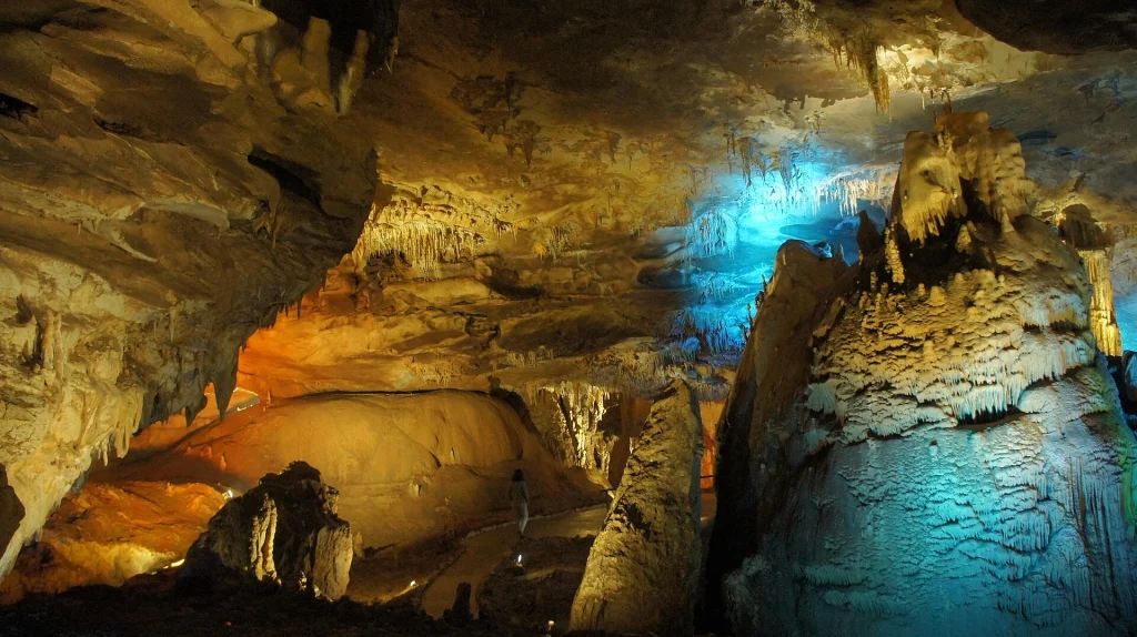
Western Georgia’s Imereti region sits on thick limestone, and limestone dissolves slowly in slightly acidic groundwater, producing karst: sinkholes, underground rivers and extensive cave systems. This is why Imereti concentrates so many of Georgia’s best-known natural sights within a short radius of Kutaisi: Prometheus Cave (Kumistavi) with its lit chambers and underground boat ride, Sataplia with fossilised dinosaur footprints and a glass-floored walkway over a karst cliff, and the river-carved Martvili and Okatse canyons with their turquoise pools and boardwalk trails. Day trips commonly combine two or three of these sites, for example Martvili & Okatse Canyons + Prometheus Cave or Prometheus Cave, Martvili Canyon and Okatse from Kutaisi, and from Batumi via Prometheus Cave and Martvili Canyon from Batumi. Cave temperatures stay cool year-round, so bring a light layer even in summer, and check ahead in winter and after heavy rain, since river levels in the canyons can affect walkway access.
Why Georgia has roughly 2,000 mineral springs
The figure of around 2,000 mineral and thermal water sources often cited for Georgia reflects the same tectonic complexity described above: folded, fractured rock of many different ages and compositions, combined with residual volcanic heat in several regions, lets groundwater pick up a wide range of dissolved minerals and gases as it circulates deep underground before resurfacing. This is why the springs vary so much in character across short distances, from the naturally carbonated cold water of Borjomi to the warm radon-carbonate baths of Tskaltubo and the sulphur springs that gave Tbilisi’s old bath district, Abanotubani, its name. Borjomi-Kharagauli National Park, one of Europe’s largest, protects much of the forested catchment around the Borjomi springs; details on access and trails are kept current by the park administration, see Georgia’s Ministry of Environmental Protection and Agriculture, which oversees the country’s protected areas. For a first visit, a day trip such as Borjomi and Bakuriani — Spa Town and Mountain Air in a Day or a longer stay on the Borjomi Spa Week covers the mineral-water side, while the Tskaltubo baths are the focus of our Tskaltubo Cure and shorter Tskaltubo Short Cure. Anyone considering balneotherapy for a specific health condition should discuss it with a doctor first, since mineral baths are not a substitute for medical treatment.
Mount Kazbek: a dormant volcano, not a myth
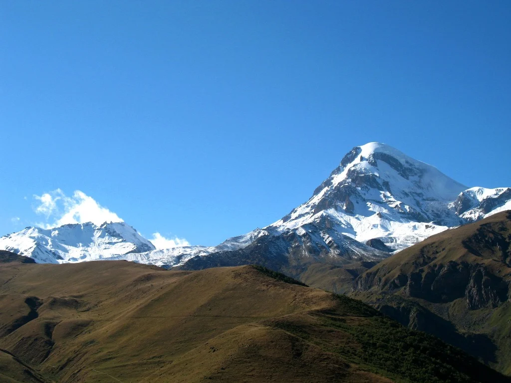
Mount Kazbek, above 5,000 metres on the border area near Stepantsminda, is a genuine stratovolcano rather than purely a folded peak, built up from past eruptions and now capped by glaciers including the Gergeti and Devdoraki ice fields. It is classed as dormant: there is no confirmed eruption in recorded history, though geologists place its last significant activity in antiquity, and estimates vary, so travellers who want a precise date should treat any single figure with caution and consult a specialist source such as Britannica’s entry on Mount Kazbek. For visitors this means a spectacular but inactive mountain, popular for the short hike to Gergeti Trinity Church and for longer treks onto the glacier itself. Options range from a day trip with the church view, such as Kazbegi — Gergeti Trinity Church in a Day, to a closer approach on Gergeti Glacier and Kazbek Base Camp, and a full technical ascent on the Mount Kazbek Summit Expedition, which should only be attempted with a certified mountain guide and proper acclimatisation.
Earthquakes: what travellers should actually know
Georgia lies in a moderately to highly seismic zone because of the same plate convergence that built the Caucasus, and small tremors are recorded regularly across the country. Most are too minor to be felt, and damaging earthquakes are infrequent, though the region has a documented history including the 1991 Racha earthquake, one of the stronger events of the past century. Seismic monitoring and hazard information is maintained by Georgia’s National Environment Agency, see nea.gov.ge, and it is worth a quick check of their site or current local news before a trip if you are travelling through a region that has had recent activity. In practice, the standard precautions apply: note the fire exits and any earthquake guidance in your hotel, avoid standing directly beneath unreinforced old masonry in historic towns immediately after a felt tremor, and follow instructions from guides and hotel staff rather than improvising.
If this guide is part of a trip you are planning, our Western Georgia in 6 Days — Kutaisi, Svaneti and the Sea and Mestia to Kutaisi or Zugdidi Transfer cover the places it describes with a private guide and driver; a GTour travel expert adapts the route to your dates.
Practical summary
- Georgia’s geology follows one cause: the Arabian plate pressing into Eurasia, which built the Caucasus, Kazbek’s volcanic cone, basalt canyons and active faults together.
- Mud volcanoes near Dedoplistsqaro, including Takhti-Tepa, are best visited with a local guide as part of a David Gareji or Vashlovani day trip; confirm current access before travelling.
- Dashbashi Canyon near Tsalka shows clear columnar basalt and is an easy, well-marked day trip from Tbilisi.
- Imereti’s limestone karst gives Georgia its best caves and canyons, Prometheus, Sataplia, Martvili and Okatse, usually combined in a single Kutaisi-based day.
- Roughly 2,000 mineral springs exist because fractured rock and residual volcanic heat let groundwater pick up varied minerals; Borjomi and Tskaltubo are the best-known destinations, and personal health decisions around spa treatment should involve a doctor.
- Mount Kazbek is a dormant stratovolcano with no confirmed historical eruption, now a trekking and climbing destination rather than an active hazard.
- Earthquakes are frequent but mostly minor; check Georgia’s National Environment Agency for current hazard information and follow normal safety practice in older buildings after any felt tremor.
- For any date-sensitive detail, cave closure, trail condition or official access rule, verify directly with the linked agency before finalising plans.
Sources
- Georgia's National Environment Agency
- Ministry of Environmental Protection and Agriculture
- Dmanisi Hominin Site and Volcanic Geology
Questions this guide does not answer? Write to info@castle.ge or WhatsApp +995 577 41 63 14 — a person in Tbilisi replies. See also our travel services and all guides.
Mount Kazbek, Georgia's dormant stratovolcano, seen with its snow-capped summit. · Photo: Lidia Ilona / Wikimedia Commons, CC BY 2.0
Been to Georgia? Tell us how it went — the best stories are published here.
Share your tripOne email a week: what changed for travellers in Georgia — rules, roads, flights, seasons — plus one place worth the trip. Written by the GTour desk, no advertising, unsubscribe in one click.
This story across our partner network — ქართულად: შენი დასვენება
